
Thank you for supporting this site ❤️
Make a donation
Make a donation
Marcinelle topographic map
Click on the map to display elevation.
Thank you for supporting this site ❤️
Make a donation
Make a donation
About this map
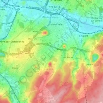
Name: Marcinelle topographic map, elevation, terrain.
Location: Marcinelle, Charleroi, Hainaut, Wallonie, 6001, Belgique (50.35284 4.41661 50.41163 4.46248)
Average elevation: 150 m
Minimum elevation: 96 m
Maximum elevation: 228 m
Thank you for supporting this site ❤️
Make a donation
Make a donation
Other topographic maps
Click on a map to view its topography, its elevation and its terrain.
Thank you for supporting this site ❤️
Make a donation
Make a donation