
Thank you for supporting this site ❤️
Make a donation
Make a donation
São Pedro da Aldeia topographic map
Click on the map to display elevation.
Thank you for supporting this site ❤️
Make a donation
Make a donation
About this map
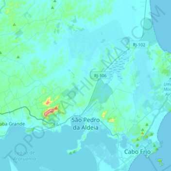
Name: São Pedro da Aldeia topographic map, elevation, terrain.
Average elevation: 16 m
Minimum elevation: -1 m
Maximum elevation: 289 m
Thank you for supporting this site ❤️
Make a donation
Make a donation
Other topographic maps
Click on a map to view its topography, its elevation and its terrain.
Rio de Janeiro
Brazil > Rio de Janeiro > Região Metropolitana do Rio de Janeiro > Rio de Janeiro
Temperature also varies according to elevation, distance from the coast, and type of vegetation or land use. During the winter, cold fronts and dawn/morning sea breezes bring mild temperatures; cold fronts, the Intertropical Convergence Zone (in the form of winds from the Amazon Forest), the strongest…
Average elevation: 40 m