
Thank you for supporting this site ❤️
Make a donation
Make a donation
Elst topographic map
Click on the map to display elevation.
Thank you for supporting this site ❤️
Make a donation
Make a donation
About this map
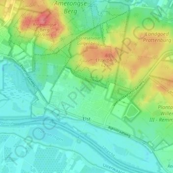
Name: Elst topographic map, elevation, terrain.
Location: Elst, Rhenen, Utrecht, Nederland (51.97157 5.47766 52.01231 5.54528)
Average elevation: 23 m
Minimum elevation: 1 m
Maximum elevation: 72 m
Thank you for supporting this site ❤️
Make a donation
Make a donation
Other topographic maps
Click on a map to view its topography, its elevation and its terrain.