
Galtåsen topographic map
Interactive map
Click on the map to display elevation.
About this map
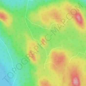
Name: Galtåsen topographic map, elevation, terrain.
Location: Galtåsen, Vansbro, Dalecarlia, Region Svealand, Sweden (60.44203 14.32252 60.44213 14.32262)
Average elevation: 315 m
Minimum elevation: 248 m
Maximum elevation: 394 m
Other topographic maps
Click on a map to view its topography, its elevation and its terrain.
Storvätteshågna
Storvätteshågna, Älvdalen, Dalecarlia, Region Svealand, Sweden
Average elevation: 1,052 m
Fjällberget
Fjällberget, Leksand, Dalecarlia, Region Svealand, Sweden
Average elevation: 445 m