
Thank you for supporting this site ❤️
Make a donation
Make a donation
Cumberland Shores topographic map
Click on the map to display elevation.
Thank you for supporting this site ❤️
Make a donation
Make a donation
About this map
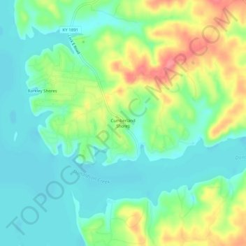
Name: Cumberland Shores topographic map, elevation, terrain.
Location: Cumberland Shores, Trigg County, Kentucky, United States (36.73227 -87.96780 36.77227 -87.92780)
Average elevation: 131 m
Minimum elevation: 104 m
Maximum elevation: 181 m
Thank you for supporting this site ❤️
Make a donation
Make a donation
Other topographic maps
Click on a map to view its topography, its elevation and its terrain.
Land Between the Lakes National Recreation Area
United States > Kentucky > Trigg County
The United States Army Corps of Engineers constructed a dam on the Cumberland, producing another lake. It was planned to be at the same elevation as Kentucky Lake, and the two rivers were to be connected by a canal that did not require locks. This project was intended to lessen the shipping distances for goods…
Average elevation: 146 m