
Thank you for supporting this site ❤️
Make a donation
Make a donation
Gamay topographic map
Click on the map to display elevation.
Thank you for supporting this site ❤️
Make a donation
Make a donation
About this map
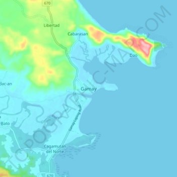
Name: Gamay topographic map, elevation, terrain.
Location: Gamay, Northern Samar, Eastern Visayas, Philippines (12.34674 125.26151 12.42674 125.34151)
Average elevation: 16 m
Minimum elevation: -3 m
Maximum elevation: 146 m
Thank you for supporting this site ❤️
Make a donation
Make a donation
Other topographic maps
Click on a map to view its topography, its elevation and its terrain.
Thank you for supporting this site ❤️
Make a donation
Make a donation
Thank you for supporting this site ❤️
Make a donation
Make a donation
Biri Larosa Protected Landscape and Seascape
Philippines > Northern Samar > Biri
Average elevation: 12 m
Thank you for supporting this site ❤️
Make a donation
Make a donation