
Thank you for supporting this site ❤️
Make a donation
Make a donation
Golden Ears Park topographic map
Click on the map to display elevation.
Thank you for supporting this site ❤️
Make a donation
Make a donation
About this map
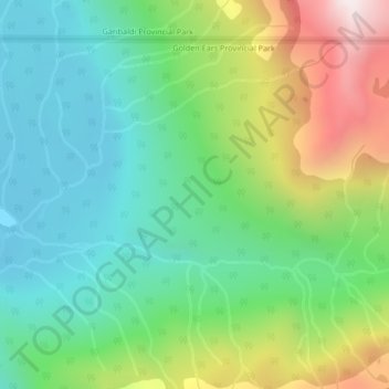
Name: Golden Ears Park topographic map, elevation, terrain.
Average elevation: 1,292 m
Minimum elevation: 951 m
Maximum elevation: 1,998 m
Thank you for supporting this site ❤️
Make a donation
Make a donation
Other topographic maps
Click on a map to view its topography, its elevation and its terrain.
Stave Lake
Canada > British Columbia > Area F (McConnell Creek/Hatzic Prairie)
Average elevation: 576 m
Kenyon Lake
Canada > British Columbia > Area F (McConnell Creek/Hatzic Prairie)
Average elevation: 765 m