
Thank you for supporting this site ❤️
Make a donation
Make a donation
Dhampus topographic map
Click on the map to display elevation.
Thank you for supporting this site ❤️
Make a donation
Make a donation
About this map
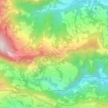
Name: Dhampus topographic map, elevation, terrain.
Average elevation: 1,456 m
Minimum elevation: 1,107 m
Maximum elevation: 1,973 m
Thank you for supporting this site ❤️
Make a donation
Make a donation
Other topographic maps
Click on a map to view its topography, its elevation and its terrain.
Phewa Lake
Nepal > Gandaki Province > Kaski > Pokhara
Phewa Lake, Phewa Tal or Fewa Lake (Nepali: फेवा ताल, [ˈpʰewa tal]) is a freshwater lake in Nepal formerly called Baidam Tal located in the south of the Pokhara Valley that includes Pokhara city and parts of Sarangkot and Kaskikot. It is the second largest lake in Nepal and the largest in…
Average elevation: 884 m