
Thank you for supporting this site ❤️
Make a donation
Make a donation
Fairfield Glade topographic map
Click on the map to display elevation.
Thank you for supporting this site ❤️
Make a donation
Make a donation
About this map
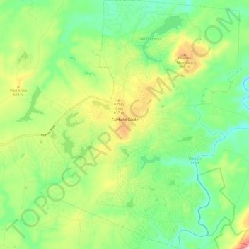
Name: Fairfield Glade topographic map, elevation, terrain.
Average elevation: 543 m
Minimum elevation: 427 m
Maximum elevation: 752 m
Thank you for supporting this site ❤️
Make a donation
Make a donation
Other topographic maps
Click on a map to view its topography, its elevation and its terrain.
Grassland Addition
United States > Tennessee > Cumberland County > Crossville
Average elevation: 560 m
Thank you for supporting this site ❤️
Make a donation
Make a donation
Thank you for supporting this site ❤️
Make a donation
Make a donation
Grassland Addition
United States > Tennessee > Cumberland County > Crossville
Average elevation: 560 m
Thank you for supporting this site ❤️
Make a donation
Make a donation