
Thank you for supporting this site ❤️
Make a donation
Make a donation
Karlstadt topographic map
Click on the map to display elevation.
Thank you for supporting this site ❤️
Make a donation
Make a donation
About this map
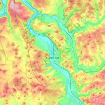
Name: Karlstadt topographic map, elevation, terrain.
Location: Karlstadt, Landkreis Main-Spessart, Beieren, 97753, Duitsland (49.91839 9.61961 50.02127 9.87122)
Average elevation: 264 m
Minimum elevation: 151 m
Maximum elevation: 422 m
Thank you for supporting this site ❤️
Make a donation
Make a donation
Other topographic maps
Click on a map to view its topography, its elevation and its terrain.