
Thank you for supporting this site ❤️
Make a donation
Make a donation
Brooks Corner topographic map
Click on the map to display elevation.
Thank you for supporting this site ❤️
Make a donation
Make a donation
About this map
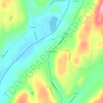
Name: Brooks Corner topographic map, elevation, terrain.
Average elevation: 397 m
Minimum elevation: 327 m
Maximum elevation: 528 m
Thank you for supporting this site ❤️
Make a donation
Make a donation
Other topographic maps
Click on a map to view its topography, its elevation and its terrain.
Village of Hamilton
United States > New York > Madison County > Town of Hamilton
The village, located at 42°49′32″N 75°32′40″W / 42.82556°N 75.54444°W / 42.82556; -75.54444 (42.825646, −75.544673), lies in the Chenango Valley, just south of the headwaters of the Chenango River. Northeast of the village is the river Payne Brook, which starts at Lake Moraine and…
Average elevation: 386 m