
Düsseldorf topographic map
Interactive map
Click on the map to display elevation.
About this map
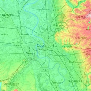
Name: Düsseldorf topographic map, elevation, terrain.
Average elevation: 63 m
Minimum elevation: 13 m
Maximum elevation: 260 m
Other topographic maps
Click on a map to view its topography, its elevation and its terrain.
Unterbach
Allemagne > Rhénanie-du-Nord-Westphalie > Düsseldorf
Unterbach, Stadtbezirk 8, Düsseldorf, Rhénanie-du-Nord-Westphalie, Allemagne
Average elevation: 57 m