
Pico Island topographic map
Interactive map
Click on the map to display elevation.
About this map
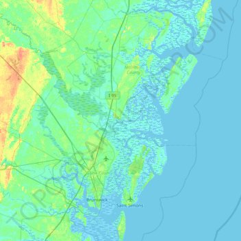
Name: Pico Island topographic map, elevation, terrain.
Location: Pico Island, McIntosh County, Georgia, 31305, USA (31.03995 -81.73760 31.67995 -81.09760)
Average elevation: 4 m
Minimum elevation: -5 m
Maximum elevation: 32 m
Other topographic maps
Click on a map to view its topography, its elevation and its terrain.
Lake Hartwell
Lake Hartwell, Cooper Valley Road, Fairview, Stephens County, Georgia, USA
Average elevation: 268 m
Lake Burton
Lake Burton, Moccasin Creek Road, Rabun County, Georgia, USA
Average elevation: 662 m
Eagle Court
USA > Georgia > Eagle Court
Eagle Court, Bulloch County, Georgia, 30460, USA
Average elevation: 62 m
Radium Springs
USA > Georgia > Radium Springs
Radium Springs, Dougherty County, Georgia, 31705, USA
Average elevation: 57 m
Winona Park
USA > Georgia > Winona Park
Winona Park, Ware County, Georgia, 31503, USA
Average elevation: 43 m
Cameron Point
USA > Georgia > Cameron Point
Cameron Point, Hall County, Georgia, 30506:30534, USA
Average elevation: 339 m
Pye Lake
USA > Georgia > Fayetteville
Pye Lake, Cornwallis Way, Sharon Heights, Cottonwood, Fayetteville, Fayette County, Georgia, 30214, USA
Average elevation: 265 m
Blackrock Mountain
Blackrock Mountain, Rabun County, Georgia, 30525, USA
Average elevation: 892 m
Lawson Creek
Lawson Creek, Banks County, Georgia, 30511:30521, USA
Average elevation: 253 m
Arabia Mountain
USA > Georgia > Stonecrest
Arabia Mountain, Stonecrest, DeKalb County, Georgia, 30058-8829, USA
Average elevation: 255 m
Wassaw National Wildlife Refuge
Wassaw National Wildlife Refuge, Chatham County, Georgia, USA
Average elevation: 2 m
Winslow Creek
Winslow Creek, Meriwether County, Georgia, 30222, USA
Average elevation: 262 m
Russ Pond
USA > Georgia > Cusseta-Chattahoochee County
Russ Pond, Sigerfoos Road, Cusseta-Chattahoochee County, Chattahoochee County, Georgia, 31905, USA
Average elevation: 89 m
Burnside River
Burnside River, Chatham County, Georgia, 31411, USA
Average elevation: 3 m
Margery Lake
Margery Lake, orange mark trail, Jasper County, Georgia, 30055, USA
Average elevation: 202 m
Hartman Lake
USA > Georgia > Garden Valley
Hartman Lake, GA 127, Garden Valley, Macon County, Georgia, 31081, USA
Average elevation: 127 m