
Howick topographic map
Interactive map
Click on the map to display elevation.
About this map
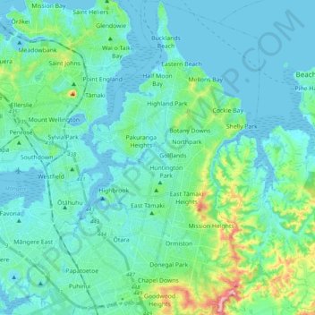
Name: Howick topographic map, elevation, terrain.
Location: Howick, Auckland, New Zealand (-37.00173 174.85646 -36.84578 174.96843)
Average elevation: 27 m
Minimum elevation: -1 m
Maximum elevation: 172 m
Other topographic maps
Click on a map to view its topography, its elevation and its terrain.
Auckland
Auckland, Waitematā, Auckland, 1010, New Zealand
Average elevation: 32 m
Te Kawa Reserve
New Zealand > Auckland > Maungakiekie-Tāmaki
Te Kawa Reserve, One Tree Hill, Maungakiekie-Tāmaki, Auckland, New Zealand
Average elevation: 58 m