
Thank you for supporting this site ❤️
Make a donation
Make a donation
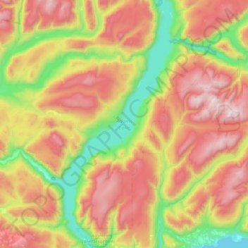
Adams Lake topographic map
Click on the map to display elevation.
Thank you for supporting this site ❤️
Make a donation
Make a donation
Adams Lake
According to one account, the lake is 63 kilometres (39 mi) long and 1.6 to 3.2 kilometres (1.0 to 2.0 mi) wide. The surface elevation is 404 metres (1,325 ft) above sea level. The mean depth of 299 metres (981 ft) and maximum depth of 457 metres (1,499 ft) make the second deepest lake in BC (next to Quesnel Lake, which has a maximum depth of 511 metres (1,677 ft)) and 7th deepest lake in the world by mean depth. Another account gives a maximum depth of 397 metres (1,302 ft) and length of 72 kilometres (45 mi).
Thank you for supporting this site ❤️
Make a donation
Make a donation
About this map
Name: Adams Lake topographic map, elevation, terrain.
Average elevation: 1,177 m
Minimum elevation: 346 m
Maximum elevation: 2,289 m
Thank you for supporting this site ❤️
Make a donation
Make a donation