
Thank you for supporting this site ❤️
Make a donation
Make a donation
Taupiri Bay topographic map
Click on the map to display elevation.
Thank you for supporting this site ❤️
Make a donation
Make a donation
About this map
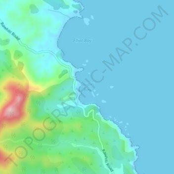
Name: Taupiri Bay topographic map, elevation, terrain.
Location: Taupiri Bay, Northland, New Zealand (-35.28138 174.29534 -35.28128 174.29544)
Average elevation: 36 m
Minimum elevation: 0 m
Maximum elevation: 229 m
Thank you for supporting this site ❤️
Make a donation
Make a donation
Other topographic maps
Click on a map to view its topography, its elevation and its terrain.
Kaeo River
New Zealand > Northland > Far North District > Bay of Islands-Whangaroa Community
Average elevation: 121 m
Thank you for supporting this site ❤️
Make a donation
Make a donation
Waiparera Stream
New Zealand > Northland > Far North District > Te Hiku Community
Average elevation: 5 m
Utakura River
New Zealand > Northland > Far North District > Kaikohe-Hokianga Community
Average elevation: 124 m
Thank you for supporting this site ❤️
Make a donation
Make a donation
Pungaere Stream
New Zealand > Northland > Far North District > Bay of Islands-Whangaroa Community
Average elevation: 183 m