
Thank you for supporting this site ❤️
Make a donation
Make a donation
Eibergen topographic map
Click on the map to display elevation.
Thank you for supporting this site ❤️
Make a donation
Make a donation
About this map
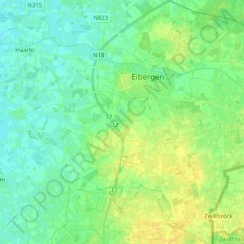
Name: Eibergen topographic map, elevation, terrain.
Location: Eibergen, Berkelland, Gelderland, Netherlands (52.04437 6.58576 52.13000 6.71129)
Average elevation: 25 m
Minimum elevation: 16 m
Maximum elevation: 39 m
Thank you for supporting this site ❤️
Make a donation
Make a donation
Other topographic maps
Click on a map to view its topography, its elevation and its terrain.
Thank you for supporting this site ❤️
Make a donation
Make a donation
Thank you for supporting this site ❤️
Make a donation
Make a donation
Thank you for supporting this site ❤️
Make a donation
Make a donation