
Thank you for supporting this site ❤️
Make a donation
Make a donation
Jasło topographic map
Click on the map to display elevation.
Thank you for supporting this site ❤️
Make a donation
Make a donation
Jasło
Jasło [ˈjaswɔ] (listen) is a county town in south-eastern Poland with 36,641 inhabitants, as of 31 December 2012. It is situated in the Subcarpathian Voivodeship (since 1999), and it was previously part of Krosno Voivodeship (1975–1998). It is located in Lesser Poland, in the heartland of the Doły (Pits), and its average altitude is 320 metres above sea level, although there are some hills located within the confines of the city. The Patron Saint of the city is Saint Anthony of Padua.
Thank you for supporting this site ❤️
Make a donation
Make a donation
About this map
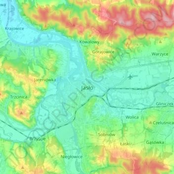
Name: Jasło topographic map, elevation, terrain.
Location: Jasło, Jasło County, Subcarpathian Voivodeship, Poland (49.71044 21.40176 49.78358 21.54169)
Average elevation: 265 m
Minimum elevation: 216 m
Maximum elevation: 378 m
Thank you for supporting this site ❤️
Make a donation
Make a donation