
Thank you for supporting this site ❤️
Make a donation
Make a donation
Bahy El deen topographic map
Click on the map to display elevation.
Thank you for supporting this site ❤️
Make a donation
Make a donation
About this map
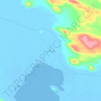
Name: Bahy El deen topographic map, elevation, terrain.
Location: Bahy El deen, Matruh, Egypt (29.24703 25.30473 29.28703 25.34473)
Average elevation: 9 m
Minimum elevation: -22 m
Maximum elevation: 118 m
Thank you for supporting this site ❤️
Make a donation
Make a donation
Other topographic maps
Click on a map to view its topography, its elevation and its terrain.
Thank you for supporting this site ❤️
Make a donation
Make a donation
Thank you for supporting this site ❤️
Make a donation
Make a donation
Thank you for supporting this site ❤️
Make a donation
Make a donation
Thank you for supporting this site ❤️
Make a donation
Make a donation
Thank you for supporting this site ❤️
Make a donation
Make a donation