
Make a donation
Harvey Lake topographic map
Click on the map to display elevation.
Make a donation
About this map
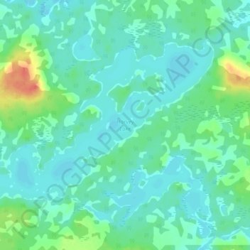
Name: Harvey Lake topographic map, elevation, terrain.
Average elevation: 297 m
Minimum elevation: 287 m
Maximum elevation: 333 m
Make a donation
Other topographic maps
Click on a map to view its topography, its elevation and its terrain.
Whitefish Lake
Canada > Ontario > Thunder Bay District > Unorganized Thunder Bay District
Average elevation: 472 m
Sunbow Lake
Canada > Ontario > Thunder Bay District > Unorganized Thunder Bay District
Average elevation: 491 m
Sulphur Lake
Canada > Ontario > Thunder Bay District > Unorganized Thunder Bay District
Average elevation: 467 m
Tower Mountain
Canada > Ontario > Thunder Bay District > Unorganized Thunder Bay District
Average elevation: 575 m
Make a donation
Trowbridge Island
Canada > Ontario > Thunder Bay District > Unorganized Thunder Bay District
Average elevation: 179 m
Joyce Lake
Canada > Ontario > Thunder Bay District > Unorganized Thunder Bay District
Average elevation: 391 m
Upsala
Canada > Ontario > Thunder Bay District > Unorganized Thunder Bay District
Average elevation: 487 m
Shebandowan
Canada > Ontario > Thunder Bay District > Unorganized Thunder Bay District
Average elevation: 461 m
Make a donation
Nolalu
Canada > Ontario > Thunder Bay District > Unorganized Thunder Bay District
Average elevation: 370 m
Tomlinson Lake
Canada > Ontario > Thunder Bay District > Unorganized Thunder Bay District
Average elevation: 489 m
Sunshine
Canada > Ontario > Thunder Bay District > Unorganized Thunder Bay District
Average elevation: 401 m
Ara Lake
Canada > Ontario > Thunder Bay District > Unorganized Thunder Bay District
Average elevation: 308 m
Make a donation
Paint Lake
Canada > Ontario > Thunder Bay District > Unorganized Thunder Bay District
Average elevation: 450 m
O'Brien Lake
Canada > Ontario > Thunder Bay District > Unorganized Thunder Bay District
Average elevation: 205 m
Timmus Lake
Canada > Ontario > Thunder Bay District > Unorganized Thunder Bay District
Average elevation: 461 m
Shabaqua Corners
Canada > Ontario > Thunder Bay District > Unorganized Thunder Bay District
Average elevation: 416 m
Make a donation
Rossport
Canada > Ontario > Thunder Bay District > Unorganized Thunder Bay District
Average elevation: 227 m
Springpole Island
Canada > Ontario > Thunder Bay District > Unorganized Thunder Bay District
Average elevation: 289 m
Cola Creek
Canada > Ontario > Thunder Bay District > Unorganized Thunder Bay District
Average elevation: 479 m
Squash Lake
Canada > Ontario > Thunder Bay District > Unorganized Thunder Bay District
Average elevation: 348 m
Make a donation
Rossport
Canada > Ontario > Thunder Bay District > Unorganized Thunder Bay District
Average elevation: 227 m
Topaz Lake
Canada > Ontario > Thunder Bay District > Unorganized Thunder Bay District
Average elevation: 482 m