Geolocate

Le Tampon topographic map

Click on the map to display elevation.

About this map
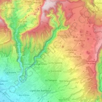
Name: Le Tampon topographic map, elevation, terrain.

Location: Le Tampon, Saint-Pierre, Réunion, France (-21.31661 55.47953 -21.13358 55.66070)

Average elevation: 1,005 m

Minimum elevation: 22 m

Maximum elevation: 2,345 m

Other topographic maps

Click on a map to view its topography, its elevation and its terrain.
Boucan-Canot

France > Réunion > Saint-Paul

Average elevation: 41 m

Ravine-Glissante

France > Réunion > Sainte-Rose

Average elevation: 87 m

La Rivière des Galets

France > Réunion > Le Port

Average elevation: 106 m

Saint-Laurent

France > Réunion > La Possession

Average elevation: 126 m

Ruisseau Blanc

France > Réunion > Saint-Denis

Average elevation: 385 m

Grand Bassin

France > Réunion > Le Tampon

Average elevation: 1,179 m

La Plaine Chabrier

France > Réunion > Saint-Paul

Average elevation: 26 m

Hell-Bourg

France > Réunion

Average elevation: 1,132 m