
Make a donation
Stuvenborn topographic map
Click on the map to display elevation.
Make a donation
About this map
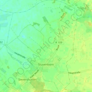
Name: Stuvenborn topographic map, elevation, terrain.
Average elevation: 27 m
Minimum elevation: 19 m
Maximum elevation: 34 m
Make a donation
Other topographic maps
Click on a map to view its topography, its elevation and its terrain.
Götzberg
Deutschland > Schleswig-Holstein > Kreis Segeberg > Henstedt-Ulzburg
Die Schleswig-Holstein-Topographie listet als Ortsteile folgende auf: Westerwohld, Vogelsang, Götzberg, Stegelkamp, Hohnerberg, Wohld, Henstedterbaum, Ellerrehm, Birkenau, Drögeneck, Horst, Hohenhorst, Rhen, Togenkamp, Ulzburg-Süd, Beckershof.
Average elevation: 49 m
Norderstedt
Deutschland > Schleswig-Holstein > Kreis Segeberg > Norderstedt > Norderstedt
Average elevation: 32 m
Make a donation
Kattendorf-Weeden
Deutschland > Schleswig-Holstein > Kreis Segeberg > Kattendorf
Average elevation: 53 m
Make a donation
Vogelsang
Deutschland > Schleswig-Holstein > Kreis Segeberg > Henstedt-Ulzburg > Götzberg
Average elevation: 49 m
Kalkberg
Deutschland > Schleswig-Holstein > Kreis Segeberg > Bad Segeberg
Ursprünglich war der Kalkberg deutlich über 110 Meter hoch und hatte eine völlig andere Gestalt als heute. Im Mittelalter stand auf dem einstigen Rücken des damals noch Alberg genannten Berges die Siegesburg. Diese Höhenburg wurde von Kaiser Lothar 1134 gegründet und im Dreißigjährigen Krieg von den…
Average elevation: 45 m
Strand Seekamp
Deutschland > Schleswig-Holstein > Kreis Segeberg > Berlin > Seekamp
Average elevation: 38 m
Make a donation
Make a donation