
Tragwein topographic map
Interactive map
Click on the map to display elevation.
About this map
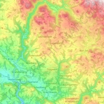
Name: Tragwein topographic map, elevation, terrain.
Location: Tragwein, Bezirk Freistadt, Oberösterreich, 4284, Österreich (48.29743 14.56333 48.39851 14.64165)
Average elevation: 494 m
Minimum elevation: 274 m
Maximum elevation: 779 m
Tragwein liegt auf 491 m Seehöhe im Mühlviertel. Die Ausdehnung des Gemeindegebiets beträgt von Nord nach Süd 11,2 km, von West nach Ost 5,7 km. Die Gesamtfläche beträgt 39,4 km², wovon 13,9 % auf Wald und 22,9 % auf landwirtschaftlich genutzte Flächen entfallen.