
Thank you for supporting this site ❤️
Make a donation
Make a donation
Herne Bay topographic map
Click on the map to display elevation.
Thank you for supporting this site ❤️
Make a donation
Make a donation
About this map
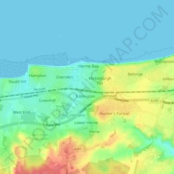
Name: Herne Bay topographic map, elevation, terrain.
Location: Herne Bay, Kent, England, United Kingdom (51.35366 1.08662 51.37642 1.17813)
Average elevation: 17 m
Minimum elevation: 0 m
Maximum elevation: 59 m
Thank you for supporting this site ❤️
Make a donation
Make a donation
Other topographic maps
Click on a map to view its topography, its elevation and its terrain.
Nelson Park
United Kingdom > England > Kent > Dover > St. Margaret's at Cliffe
Average elevation: 69 m
Thank you for supporting this site ❤️
Make a donation
Make a donation
White Cliffs of Dover
United Kingdom > England > Kent > Dover > St. Margaret's at Cliffe
Average elevation: 49 m
Thank you for supporting this site ❤️
Make a donation
Make a donation
Thank you for supporting this site ❤️
Make a donation
Make a donation
Thank you for supporting this site ❤️
Make a donation
Make a donation
Thank you for supporting this site ❤️
Make a donation
Make a donation
Park Gate
United Kingdom > England > Kent > Folkestone and Hythe District > Elham
Average elevation: 130 m