
Gangotri Glacier topographic map
Interactive map
Click on the map to display elevation.
About this map
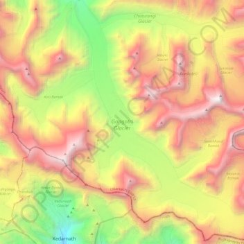
Name: Gangotri Glacier topographic map, elevation, terrain.
Location: Gangotri Glacier, Bhatwari, Uttarkashi, Uttarakhand, Inde (30.73027 79.07689 30.92663 79.27806)
Average elevation: 5,259 m
Minimum elevation: 3,530 m
Maximum elevation: 7,020 m
Other topographic maps
Click on a map to view its topography, its elevation and its terrain.
Meru Peak
Inde > Uttarakhand > Bhatwari
Meru Peak, Bhatwari, Uttarkashi district, Uttarakhand, Inde
Average elevation: 5,738 m
Sri Kailas West
Inde > Uttarakhand > Bhatwari
Sri Kailas West, Bhatwari, Uttarkashi district, Uttarakhand, Inde
Average elevation: 6,080 m
Satopanth
Inde > Uttarakhand > Bhatwari
Satopanth, Bhatwari, Uttarkashi district, Uttarakhand, Inde
Average elevation: 6,094 m
Bhaironghati
Inde > Uttarakhand > Bhatwari > Lanka > Bhaironghati
Bhaironghati, Lanka, Bhatwari, Uttarkashi, Uttarakhand, Inde
Average elevation: 3,227 m