
Make a donation
Aalen topographic map
Click on the map to display elevation.
Make a donation
Aalen
The elevation in the centre of the market square is 430 m (1,410 ft) relative to Normalhöhennull. The territory's lowest point is at the Lein river near Rodamsdörfle, the highest point is the Grünberg's peak near Unterkochen at 733 m (2,405 ft).
Make a donation
About this map
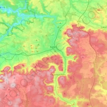
Name: Aalen topographic map, elevation, terrain.
Average elevation: 554 m
Minimum elevation: 359 m
Maximum elevation: 771 m
Make a donation
Other topographic maps
Click on a map to view its topography, its elevation and its terrain.
Wilflingen
Germany > Baden-Württemberg > Ostalbkreis > Abtsgmünd
The main town of Abtsgmünd lies at the confluence of the Lein river into the Kocher (confluence elevation 367.4 m above sea level), predominantly on the left bank of the Kocher and left bank of the Lein. The furthest district of Untergröningen lies over 8 km west-northwest as the crow flies along two river…
Average elevation: 432 m
Kapfenburg
Germany > Baden-Württemberg > Ostalbkreis > Lauchheim > Domäne Kapfenburg
Average elevation: 559 m
Make a donation