
Thank you for supporting this site ❤️
Make a donation
Make a donation
Pandatung topographic map
Click on the map to display elevation.
Thank you for supporting this site ❤️
Make a donation
Make a donation
About this map
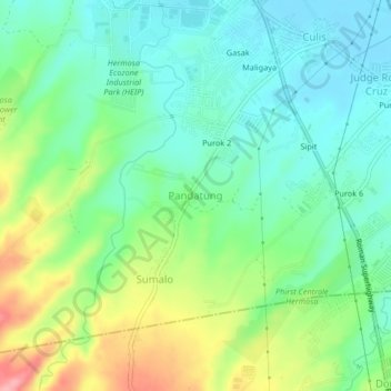
Name: Pandatung topographic map, elevation, terrain.
Location: Pandatung, Hermosa, Bataan, Central Luzon, 2111, Philippines (14.80258 120.44820 14.84258 120.48820)
Average elevation: 44 m
Minimum elevation: 5 m
Maximum elevation: 126 m
Thank you for supporting this site ❤️
Make a donation
Make a donation