Goldsby topographic map
Interactive map
Click on the map to display elevation.
About this map
![Goldsby topographic map, elevation, terrain](/pub/maps/relation/v2cz/xr63l/thumbnail.jpg)
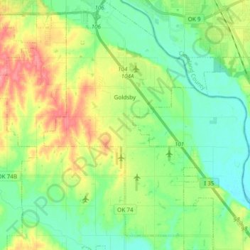
Name: Goldsby topographic map, elevation, terrain.
Location: Goldsby, McClain County, Oklahoma, United States (35.06620 -97.52550 35.18843 -97.42409)
Average elevation: 350 m
Minimum elevation: 321 m
Maximum elevation: 402 m
Other topographic maps
Click on a map to view its topography, its elevation and its terrain.
![Byars topographic map, elevation, terrain](/pub/maps/relation/6ff3/h6nrr/icon.jpg)
Byars
United States > Oklahoma > McClain County
Byars, McClain County, Oklahoma, United States
Average elevation: 315 m
![Rosedale topographic map, elevation, terrain](/pub/maps/relation/tvrr/fb8nh/icon.jpg)
Rosedale
United States > Oklahoma > McClain County
Rosedale, McClain County, Oklahoma, United States
Average elevation: 316 m
![Wayne topographic map, elevation, terrain](/pub/maps/relation/kd3l/fb81h/icon.jpg)
Wayne
United States > Oklahoma > McClain County
Wayne, McClain County, Oklahoma, United States
Average elevation: 333 m
![Purcell topographic map, elevation, terrain](/pub/maps/relation/rwtj/jnd5k/icon.jpg)
Purcell
United States > Oklahoma > McClain County
Purcell, McClain County, Oklahoma, United States
Average elevation: 333 m
![Blanchard topographic map, elevation, terrain](/pub/maps/relation/7sb3/vlztj/icon.jpg)
Blanchard
United States > Oklahoma > McClain County
Blanchard, McClain County, Oklahoma, 73010, United States
Average elevation: 384 m
![Newcastle topographic map, elevation, terrain](/pub/maps/relation/3w1h/7jj18/icon.jpg)
Newcastle
United States > Oklahoma > McClain County
Newcastle, McClain County, Oklahoma, 73065, United States
Average elevation: 373 m