
Thank you for supporting this site ❤️
Make a donation
Make a donation
Quennell Lake topographic map
Click on the map to display elevation.
Thank you for supporting this site ❤️
Make a donation
Make a donation
About this map
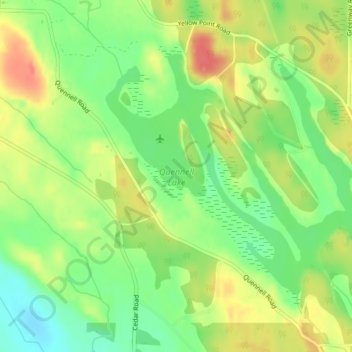
Name: Quennell Lake topographic map, elevation, terrain.
Average elevation: 40 m
Minimum elevation: 11 m
Maximum elevation: 71 m
Thank you for supporting this site ❤️
Make a donation
Make a donation
Other topographic maps
Click on a map to view its topography, its elevation and its terrain.
Cedar
Canada > British Columbia > Regional District of Nanaimo > Area A (Cassidy/Cedar)
Average elevation: 27 m
Cassidy
Canada > British Columbia > Regional District of Nanaimo > Area A (Cassidy/Cedar) > Cassidy
Average elevation: 50 m
Cedar
Canada > British Columbia > Regional District of Nanaimo > Area A (Cassidy/Cedar)
Average elevation: 27 m