
Thank you for supporting this site ❤️
Make a donation
Make a donation
Mierzeszyn topographic map
Click on the map to display elevation.
Thank you for supporting this site ❤️
Make a donation
Make a donation
About this map
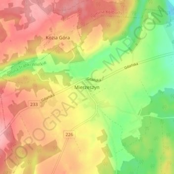
Name: Mierzeszyn topographic map, elevation, terrain.
Average elevation: 208 m
Minimum elevation: 140 m
Maximum elevation: 265 m
Thank you for supporting this site ❤️
Make a donation
Make a donation
Other topographic maps
Click on a map to view its topography, its elevation and its terrain.
Pruszcz Gdański
Poland > Pomeranian Voivodeship > Gdańsk County > Pruszcz Gdański
Average elevation: 11 m
Thank you for supporting this site ❤️
Make a donation
Make a donation