
Neyruz (FR) topographic map
Interactive map
Click on the map to display elevation.
About this map
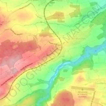
Name: Neyruz (FR) topographic map, elevation, terrain.
Location: Neyruz (FR), District de la Sarine, Fribourg, 1740, Suisse (46.75343 7.04329 46.77894 7.09131)
Average elevation: 683 m
Minimum elevation: 596 m
Maximum elevation: 758 m
Other topographic maps
Click on a map to view its topography, its elevation and its terrain.
Neyruz FR
Suisse > Fribourg > District de la Sarine > Neyruz (FR)
Neyruz FR, Neyruz (FR), District de la Sarine, Fribourg, 1740, Suisse
Average elevation: 682 m