
Haute Cime topographic map
Interactive map
Click on the map to display elevation.
About this map
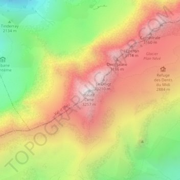
Name: Haute Cime topographic map, elevation, terrain.
Location: Haute Cime, Val-d'Illiez, Monthey, Valais, 1873, Suisse (46.16109 6.92321 46.16119 6.92331)
Average elevation: 2,539 m
Minimum elevation: 1,759 m
Maximum elevation: 3,251 m
Other topographic maps
Click on a map to view its topography, its elevation and its terrain.
Dents du Midi
Suisse > Valais > Val-d'Illiez
Dents du Midi, Val-d'Illiez, Monthey, Valais, 1873, Suisse
Average elevation: 2,440 m