
Make a donation
Cairngorm Mountains topographic map
Click on the map to display elevation.
Make a donation
Cairngorm Mountains
In terms of height, remoteness and the severe and changeable weather, the Cairngorms are the most arduous area in the United Kingdom. The plateau area has a Tundra climate (Köppen ET), and the shattered terrain is more like the high ground in high-arctic Canada or northern Norway than what is often observed in the European Alps or Rockies. The weather often deteriorates rapidly with altitude so that, when there are moderate conditions 150 m (490 ft) below the plateau, the top can be stormy or misty, and there can be icy or powdery snow. Even when no snow is falling, the wind can whip up lying snow to produce white-out conditions for a few metres above the surface, and snowdrifts can build up rapidly in sheltered places. Gravel can be blown through the air, and walking can be impossible.
Make a donation
About this map
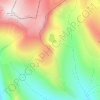
Name: Cairngorm Mountains topographic map, elevation, terrain.
Location: Cairngorm Mountains, Aberdeenshire, Scotland, United Kingdom (57.05995 -3.65005 57.06005 -3.64995)
Average elevation: 937 m
Minimum elevation: 592 m
Maximum elevation: 1,312 m
Make a donation
Other topographic maps
Click on a map to view its topography, its elevation and its terrain.
Cairngorm Mountains
United Kingdom > Scotland > Aberdeenshire
In terms of height, remoteness and the severe and changeable weather, the Cairngorms are the most arduous area in the United Kingdom. The plateau area has a Tundra climate (Köppen ET), and the shattered terrain is more like the high ground in high-arctic Canada or northern Norway than what is often observed…
Average elevation: 619 m
Make a donation
Make a donation
Dunnottar Castle
United Kingdom > Scotland > Aberdeenshire > Stonehaven > Mains of Dunnottar
Average elevation: 33 m
Make a donation
Make a donation
Glen Tanar
United Kingdom > Scotland > Aberdeenshire > Aboyne
Glen Tanar, along with the side glens formed by the Water of Gairney and the Water of Allachy, comprises the third largest area of Caledonian Forest in Scotland, which grows from the valley floor up to an altitude of 450 metres. As a Caledonian Forest, the predominant tree species is Scots pine, although…
Average elevation: 389 m
Make a donation
Make a donation