
Mittelallalin topographic map
Interactive map
Click on the map to display elevation.
About this map
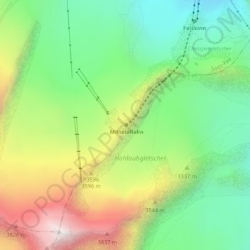
Name: Mittelallalin topographic map, elevation, terrain.
Location: Mittelallalin, Saas-Fee, Viège, Valais, 3906, Suisse (46.05750 7.90483 46.05760 7.90493)
Average elevation: 3,272 m
Minimum elevation: 2,802 m
Maximum elevation: 4,021 m
Other topographic maps
Click on a map to view its topography, its elevation and its terrain.
Lenzspitze
Lenzspitze, Saas-Fee, Viège, Valais, 3906, Suisse
Average elevation: 3,714 m
Allalinhorn
Allalinhorn, Saas-Fee, Viège, Valais, 3906, Suisse
Average elevation: 3,490 m