
Mount Katahdin topographic map
Interactive map
Click on the map to display elevation.
About this map
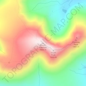
Name: Mount Katahdin topographic map, elevation, terrain.
Location: Mount Katahdin, Piscataquis County, Maine, USA (45.90303 -68.91908 45.90313 -68.91898)
Average elevation: 1,197 m
Minimum elevation: 854 m
Maximum elevation: 1,590 m
Other topographic maps
Click on a map to view its topography, its elevation and its terrain.
Acadia National Park
USA > Maine > Otter Creek
Acadia National Park, Schiff Path, Otter Creek, Hancock County, Maine, 04609, USA
Average elevation: 9 m
Cataract Dam
Cataract Dam, Saco, York County, Maine, 04072, USA
Average elevation: 22 m
Cliff Island
USA > Maine > Cliff Island
Cliff Island, Cumberland County, Maine, 04019, USA
Average elevation: 1 m
Flagstaff Hut
Flagstaff Hut, Maine Huts Trail, Somerset County, Maine, USA
Average elevation: 351 m
Green Islands
Green Islands, Southport, Lincoln County, Maine, USA
Average elevation: 4 m
Saddleback Mountain
Saddleback Mountain, Aroostook County, Maine, USA
Average elevation: 359 m