
Thank you for supporting this site ❤️
Make a donation
Make a donation
Lichtel topographic map
Click on the map to display elevation.
Thank you for supporting this site ❤️
Make a donation
Make a donation
About this map
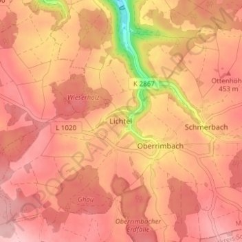
Name: Lichtel topographic map, elevation, terrain.
Average elevation: 440 m
Minimum elevation: 335 m
Maximum elevation: 478 m
Thank you for supporting this site ❤️
Make a donation
Make a donation
Other topographic maps
Click on a map to view its topography, its elevation and its terrain.
Waldmannshofen
Deutschland > Baden-Württemberg > Main-Tauber-Kreis > Creglingen
Average elevation: 331 m
Thank you for supporting this site ❤️
Make a donation
Make a donation