
Make a donation
Poprad topographic map
Click on the map to display elevation.
Make a donation
Poprad
Poprad lies at an altitude of 672 metres (2,205 ft) above sea level and covers an area of 63 square kilometres (24.3 sq mi). It is located in northeastern Slovakia, about 110 kilometres (68 mi) from Košice and 330 kilometres (205 mi) from Bratislava (by road).
Make a donation
About this map
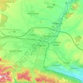
Name: Poprad topographic map, elevation, terrain.
Location: Poprad, District of Poprad, Region of Prešov, Slovakia (49.01101 20.21939 49.10672 20.37461)
Average elevation: 709 m
Minimum elevation: 576 m
Maximum elevation: 1,012 m
Make a donation
Other topographic maps
Click on a map to view its topography, its elevation and its terrain.
Rysy
Slovakia > Region of Prešov > District of Poprad > Vysoké Tatry
It is possible to reach the peak from the Slovak side, starting at Štrbské pleso and passing Chata pod Rysmi, a mountain chalet at an altitude of 2,250 m (7,380 ft). Between November 1 and June 15, the trail and chalet on the Slovak side are closed.
Average elevation: 2,005 m