
Belleville topographic map
Interactive map
Click on the map to display elevation.
About this map
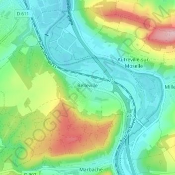
Name: Belleville topographic map, elevation, terrain.
Average elevation: 236 m
Minimum elevation: 178 m
Maximum elevation: 367 m
Other topographic maps
Click on a map to view its topography, its elevation and its terrain.
Bouxières-aux-Dames
France > Grand Est > Meurthe-et-Moselle
Bouxières-aux-Dames, Nancy, Meurthe-et-Moselle, Grand Est, Metropolitan France, 54136, France
Average elevation: 271 m
Saint-Martin
France > Grand Est > Meurthe-et-Moselle
Saint-Martin, Lunéville, Meurthe-et-Moselle, Grand Est, Metropolitan France, 54450, France
Average elevation: 262 m
Courcelles
France > Grand Est > Meurthe-et-Moselle
Courcelles, Toul, Meurthe-et-Moselle, Grand Est, Metropolitan France, 54930, France
Average elevation: 338 m