
Thank you for supporting this site ❤️
Make a donation
Make a donation
Les Maisons topographic map
Click on the map to display elevation.
Thank you for supporting this site ❤️
Make a donation
Make a donation
About this map
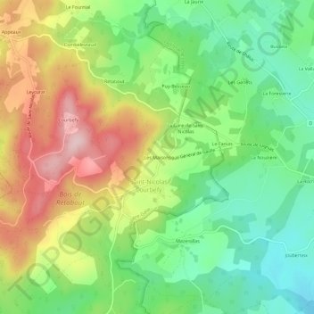
Name: Les Maisons topographic map, elevation, terrain.
Average elevation: 411 m
Minimum elevation: 308 m
Maximum elevation: 555 m
Thank you for supporting this site ❤️
Make a donation
Make a donation
Other topographic maps
Click on a map to view its topography, its elevation and its terrain.
Saint-Nicolas-Courbefy
France > Nouvelle-Aquitaine > Haute-Vienne > Bussière-Galant
Average elevation: 402 m