
Thank you for supporting this site ❤️
Make a donation
Make a donation
Aibonito topographic map
Click on the map to display elevation.
Thank you for supporting this site ❤️
Make a donation
Make a donation
Aibonito
Aibonito is located at a relatively high elevation (its main square is the highest in the island at 2,401 ft [731 m] above sea level), which makes its climate cooler than most of Puerto Rico's towns.
Thank you for supporting this site ❤️
Make a donation
Make a donation
About this map
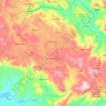
Name: Aibonito topographic map, elevation, terrain.
Location: Aibonito, Puerto Rico, United States (18.07597 -66.32063 18.18038 -66.21640)
Average elevation: 515 m
Minimum elevation: 150 m
Maximum elevation: 839 m
Thank you for supporting this site ❤️
Make a donation
Make a donation
Other topographic maps
Click on a map to view its topography, its elevation and its terrain.