
Exochori topographic map
Interactive map
Click on the map to display elevation.
About this map
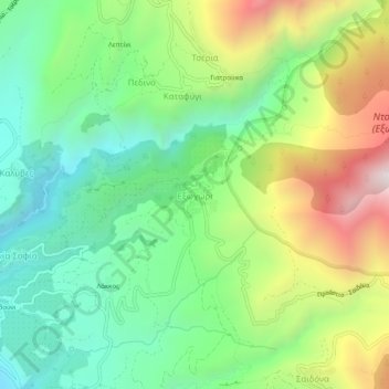
Name: Exochori topographic map, elevation, terrain.
Average elevation: 501 m
Minimum elevation: 62 m
Maximum elevation: 1,279 m
Other topographic maps
Click on a map to view its topography, its elevation and its terrain.
Stoupa
Greece > Peloponnese, Western Greece and the Ionian > Messenia Regional Unit > Municipal Unit of Lefktro
Stoupa, Municipal Unit of Lefktro, Municipality of West Mani, Messenia Regional Unit, Peloponnese Region, Peloponnese, Western Greece and the Ionian, 240 24, Greece
Average elevation: 63 m