
Thank you for supporting this site ❤️
Make a donation
Make a donation
South Thompson River topographic map
Click on the map to display elevation.
Thank you for supporting this site ❤️
Make a donation
Make a donation
About this map
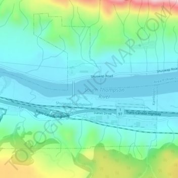
Name: South Thompson River topographic map, elevation, terrain.
Average elevation: 421 m
Minimum elevation: 337 m
Maximum elevation: 694 m
Thank you for supporting this site ❤️
Make a donation
Make a donation
Other topographic maps
Click on a map to view its topography, its elevation and its terrain.
Kamloops
Canada > British Columbia > Thompson-Nicola Regional District > Kamloops
Average elevation: 875 m