
Serralunga d'Alba topographic map
Interactive map
Click on the map to display elevation.
About this map
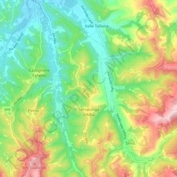
Name: Serralunga d'Alba topographic map, elevation, terrain.
Location: Serralunga d'Alba, Cuneo, Piemont, Italien (44.58895 7.97749 44.64782 8.01037)
Average elevation: 333 m
Minimum elevation: 196 m
Maximum elevation: 561 m
Der Ort liegt circa 58 km von der Provinzhauptstadt Cuneo entfernt auf einer Höhe von 414 m über dem Meeresspiegel. Das Gemeindegebiet umfasst eine Fläche von 8,44 km².
Other topographic maps
Click on a map to view its topography, its elevation and its terrain.
Villafalletto
Villafalletto, Cuneo, Piemont, Italien
Average elevation: 415 m
Monviso
Italien > Piemont > Cuneo > Pontechianale
Monviso, Pontechianale, Cuneo, Piemont, Italien
Average elevation: 2,985 m