
Make a donation
Riske Creek topographic map
Click on the map to display elevation.
Make a donation
About this map
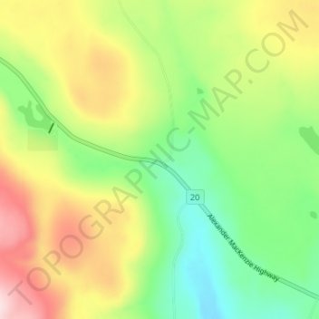
Name: Riske Creek topographic map, elevation, terrain.
Average elevation: 953 m
Minimum elevation: 824 m
Maximum elevation: 1,136 m
Make a donation
Other topographic maps
Click on a map to view its topography, its elevation and its terrain.
Horse Lake
Canada > British Columbia > Cariboo Regional District > Area K (East Chilcotin)
Average elevation: 1,938 m
Twan Lake
Canada > British Columbia > Cariboo Regional District > Area K (East Chilcotin)
Average elevation: 941 m
Mons Lake
Canada > British Columbia > Cariboo Regional District > Area K (East Chilcotin)
Average elevation: 1,166 m
Big Creek
Canada > British Columbia > Cariboo Regional District > Area K (East Chilcotin)
Average elevation: 2,031 m
Make a donation
Mons Lake
Canada > British Columbia > Cariboo Regional District > Area K (East Chilcotin)
Average elevation: 1,166 m
Stum Lake
Canada > British Columbia > Cariboo Regional District > Area K (East Chilcotin)
Average elevation: 1,211 m