
Logan County topographic map
Interactive map
Click on the map to display elevation.
About this map
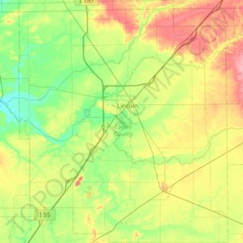
Name: Logan County topographic map, elevation, terrain.
Location: Logan County, Illinois, Estados Unidos (39.91583 -89.60404 40.32632 -89.14346)
Average elevation: 184 m
Minimum elevation: 153 m
Maximum elevation: 238 m
Other topographic maps
Click on a map to view its topography, its elevation and its terrain.
Springfield
Estados Unidos > Illinois > Springfield
Springfield, Sangamon County, Illinois, Estados Unidos
Average elevation: 178 m
Silver Springs State Fish and Wildlife Area
Estados Unidos > Illinois > Fox
Silver Springs State Fish and Wildlife Area, River Road, Fox, Kendall County, Illinois, 60545, Estados Unidos
Average elevation: 188 m