
Thank you for supporting this site ❤️
Make a donation
Make a donation
Le Rondic topographic map
Click on the map to display elevation.
Thank you for supporting this site ❤️
Make a donation
Make a donation
About this map
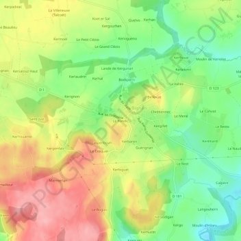
Name: Le Rondic topographic map, elevation, terrain.
Average elevation: 121 m
Minimum elevation: 64 m
Maximum elevation: 182 m
Thank you for supporting this site ❤️
Make a donation
Make a donation
Other topographic maps
Click on a map to view its topography, its elevation and its terrain.
Château de Kerguéhennec
France > Bretagne > Morbihan > Bignan > L'Étang Blanc
Average elevation: 103 m