
Chinameca topographic map
Interactive map
Click on the map to display elevation.
About this map
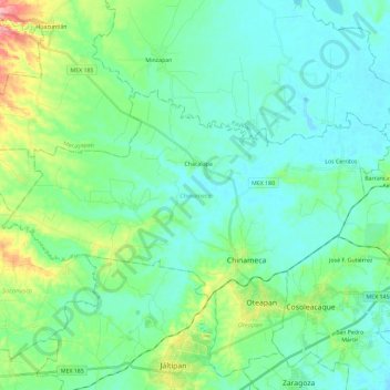
Name: Chinameca topographic map, elevation, terrain.
Location: Chinameca, Veracruz, Mexiko (18.00096 -94.81959 18.11987 -94.58786)
Average elevation: 28 m
Minimum elevation: -1 m
Maximum elevation: 129 m
Other topographic maps
Click on a map to view its topography, its elevation and its terrain.
El Ortigal
El Ortigal, Terrenos de la Ex- hacienda "Santa Clara", Papantla, Veracruz, Mexiko
Average elevation: 36 m
Fraccionamiento Tres Pasos
Mexiko > Veracruz > Emiliano Zapata > Jacarandas
Fraccionamiento Tres Pasos, Jacarandas, Emiliano Zapata, Veracruz, 91637, Mexiko
Average elevation: 1,134 m