
Sagadahoc County topographic map
Interactive map
Click on the map to display elevation.
About this map
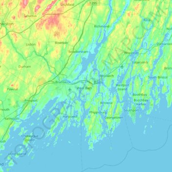
Name: Sagadahoc County topographic map, elevation, terrain.
Location: Sagadahoc County, Maine, United States of America (43.63424 -70.05203 44.16810 -69.66475)
Average elevation: 30 m
Minimum elevation: -4 m
Maximum elevation: 225 m
Other topographic maps
Click on a map to view its topography, its elevation and its terrain.
Piscataquis County
United States of America > Maine
Piscataquis County, Maine, United States of America
Average elevation: 310 m
Androscoggin County
United States of America > Maine
Androscoggin County, Maine, United States of America
Average elevation: 123 m