
Logan City topographic map
Interactive map
Click on the map to display elevation.
About this map
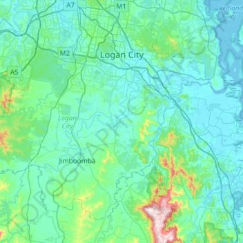
Name: Logan City topographic map, elevation, terrain.
Location: Logan City, Queensland, Australia (-27.93861 152.79948 -27.58731 153.29035)
Average elevation: 61 m
Minimum elevation: -2 m
Maximum elevation: 570 m
Other topographic maps
Click on a map to view its topography, its elevation and its terrain.
Logan City
Australia > Queensland > Logan City
Logan City, Queensland, 4114, Australia
Average elevation: 30 m