
Make a donation
Attapeu topographic map
Click on the map to display elevation.
Make a donation
Attapeu
Dong Ampham National Biodiversity Conservation Area (NBCA) lies partly in Attapeu province (for the northeastern part) and Sekong province (for the southeastern part), on the border with Vietnam. The NBCA is forested and covers about 200,000 hectares. Established in 1993, it is one of the 23 National Biodiversity Conservation Areas of Laos. Dong Ampham is home to "some of the last intact areas of lowland and tropical forests remaining in mainland Southeast Asia." Topographical features include the Xe Kaman and Xe Xou Rivers, and the volcanic lake Nong Fa Lake. Tigers and Clouded leopard have been recorded here.
Make a donation
About this map
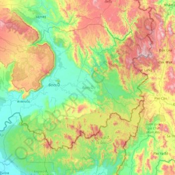
Name: Attapeu topographic map, elevation, terrain.
Location: Attapeu, Laos (14.29232 106.17017 15.28861 107.59147)
Average elevation: 599 m
Minimum elevation: 62 m
Maximum elevation: 1,967 m
Make a donation
Other topographic maps
Click on a map to view its topography, its elevation and its terrain.
Make a donation
Make a donation
Saphangmo
Laos > Vientiane Prefecture > Xaysetha District > Vientiane Capital
Average elevation: 170 m
Donnokkhoum
Laos > Vientiane Prefecture > Sisattanak District > Vientiane Capital
Average elevation: 170 m
Make a donation
Phonsinouan
Laos > Vientiane Prefecture > Sisattanak District > Vientiane Capital
Average elevation: 170 m
Make a donation
Nongtaeng
Laos > Vientiane Prefecture > Sikhottabong District > Vientiane Capital
Average elevation: 174 m
Make a donation
Dongkhamxang
Laos > Vientiane Prefecture > Hadxayfong District > Vientiane Capital
Average elevation: 172 m
Nonghai
Laos > Vientiane Prefecture > Hadxayfong District > Vientiane Capital
Average elevation: 172 m
Make a donation
Muangvatha
Laos > Vientiane Prefecture > Sikhottabong District > Vientiane Capital
Average elevation: 169 m
Dognaxoyneua
Laos > Vientiane Prefecture > Sikhottabong District > Vientiane Capital
Average elevation: 169 m
Make a donation
ທົ່ງປົງ
Laos > Vientiane Prefecture > Sikhottabong District > Vientiane Capital
Average elevation: 174 m
Nongtha Marsh
Laos > Vientiane Prefecture > Chanthabuly District > Vientiane Capital > B. Nongthanua
Average elevation: 175 m
Make a donation
Don Koy
Laos > Vientiane Prefecture > Sisattanak District > Vientiane Capital
Average elevation: 169 m
Chommanytai
Laos > Vientiane Prefecture > Xaysetha District > Vientiane Capital
Average elevation: 172 m
Make a donation
Make a donation
Make a donation
Dongphosy
Laos > Vientiane Prefecture > Hadxayfong District > Vientiane Capital
Average elevation: 168 m
Make a donation
Make a donation
Make a donation
Make a donation
Make a donation
B. Haysok
Laos > Vientiane Prefecture > Chanthabuly District > Vientiane Capital
Average elevation: 170 m
Make a donation
Thatlouangkang
Laos > Vientiane Prefecture > Xaysetha District > Vientiane Capital
Average elevation: 170 m
Make a donation
Make a donation
Make a donation
Make a donation
Make a donation
Sibounheuang
Laos > Vientiane Prefecture > Chanthabuly District > Sibounheuang
Average elevation: 171 m
Make a donation
Xiangkhouang
Xiangkhouang province covers an area of 15,880 square kilometres (6,130 sq mi) and is mountainous. Apart from floodplains, the largest area of level land in the country is on the province's Xiangkhoang Plateau. The plateau is characterized by rolling hills and grassland whose elevation averages 1,300 metres…
Average elevation: 565 m
Make a donation
Make a donation